


le tilleul mardi

Laurent53
Gebruiker
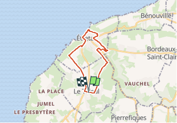

Lengte
10,5 km

Max. hoogte
111 m

Positief hoogteverschil
203 m
Km-Effort
13,2 km

Min. hoogte
4 m

Negatief hoogteverschil
206 m
Boucle
Ja
Datum van aanmaak :
2025-03-25 13:05:27.747
Laatste wijziging :
2025-03-25 16:17:30.521
3h11
Moeilijkheid : Moeilijk

Gratisgps-wandelapplicatie
 SityTrail
IGN / Geografische instituten
SityTrail Plus
De wereld gaat voor u open
Over ons
Tocht Stappen van 10,5 km beschikbaar op Normandië, Seine-Maritime, Le Tilleul. Deze tocht wordt voorgesteld door Laurent53.
Plaatsbepaling
Land:
France
Regio :
Normandië
Departement/Provincie :
Seine-Maritime
Gemeente :
Le Tilleul
Locatie:
Unknown
Vertrek:(Dec)
Vertrek:(UTM)
298370 ; 5507119 (31U) N.
Opmerkingen